Revolutionizing the Skies: The Latest Advancements & Applications of Drone Technology


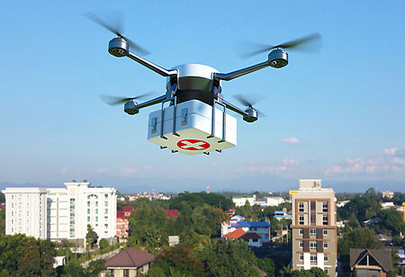
Drones can save lives! A drone recently saved a heart attack victim's life in Sweden. The drone with a defibrillator on board was used to save the life of a 71-year-old man who suffered a heart attack in December while shoveling snow. The man was revived by a physician following the use of a defibrillator by a drone. Unsurprisingly, the drone did not carry out the maneuver that would have saved a life, but instead, it delivered the life-saving equipment before an ambulance and other rescue personnel could reach the scene. The man was revived by a physician following the use of a defibrillator by a drone. The global market size of the drone is expected to reach $29.86 billion in 2022. It is anticipated to expand at a compound annual growth rate (CAGR) of 38.6 percent from 2023 to 2030. Drones are used for a wide range of applications, including filming and emergency response.
According to reports, India’s UAV market was valued at $830 million, and it is projected to grow at a compound annual growth rate (CAGR) of 14.5 percent during the 2021–2026 period, despite the effects of the global pandemic on many sectors of the economy. The Indian UAV market has the potential to cross $900 million by the end of 2021, which is significant given the global market for UAVs rests at $21.47 billion.
Latest Trends in the Drone Industry
Growing Use in Agricultural Activities
Drones are used by farmers to track everything from the weather to crop patterns, animals, and fertilization. According to estimates, drones can apply fertilizer 40–60 times faster than humans. A wide range of crop-monitoring alternatives are available at a lower cost thanks to drone technology. Drones may be used throughout the whole agricultural lifespan, from soil analysis and seeding to figuring out when to harvest the produce at its best. This would assist in changing food production techniques to meet the demand brought on by population expansion.
Rising Adoption by Law Enforcement Agencies
Drones are used by the police in a range of operations, such as the monitoring of sizable open spaces, the resolution of hostage situations, the pursuit of armed individuals, and the examination of bomb threats. UAVs offer thorough photos and documentation of properties in addition to monitoring and quick response, supporting effective data analysis, risk detection, and security planning. They are a cutting-edge and cost-effective replacement for helicopters, which may be prohibitively expensive and occasionally hard to get.
Growing use in Aerial Photography and Entertainment
Drones are frequently used to film documentaries, for private and public videography, and to shoot news footage when people cannot (like fires or other emergencies). Drone piloting is a popular activity and form of entertainment. In 2025, the market is anticipated to be valued at $3.26 billion, expanding at a CAGR of nine percent. The advantages drones provide this industry may pique the interest of private equity and venture capital investors.
Monitoring Renewable Energy Sources
Climate change is a major influence on future policy and is a growing worry on a worldwide scale. Many businesses will now want to include renewable energy sources as awareness grows. However, it is a tremendous undertaking, to put it mildly, to select a suitable location for an energy strategy and then sketch it out. Drones will be of great assistance in surveying and mapping vast fields to identify the regions ideal for wind turbines or solar panels. Drones' thermographic imaging capabilities will also aid in the 24/7 surveillance of these locations.
Drones in Digital-Twins
Digital-Twin is the term for a scaled-down replica or virtual representation of a real-world item with established parameters such as size, color, temperature, and wall thickness. Digital twins are extensively employed before building large-scale properties since they are extremely important for the infrastructure industry. Drones can revolutionize digital twin technologies by taking in-depth pictures of any given physical object. They can deliver with the highest level of precision and energy. Additionally, they may record 360 degrees of the actual object and make the data gathered valuable.
In the Bharat Drone Mahotsav, Prime Minister Narendra Modi says, “Till a few months back, there were a lot of restrictions on drones. We have removed most of the restrictions in a very short time. We are also moving towards creating a strong drone manufacturing ecosystem in India through schemes like PLI.”
According to the PM, "Drones will help in the quick delivery of medicines. We have already seen it in the delivery of vaccines in tough terrains.”
Aerial LiDAR
LiDAR technology has advanced significantly in recent years. The word LiDAR, which stands for Light Detection and Ranging, is frequently used to gather information on various surfaces and create 3D models. More use cases are already emerging as LiDAR sensors become generally available. A confluence of drone and LiDAR technologies is also being signaled by the growing use of drones. Previously, to map the ground below, LiDAR was either employed by helicopters, aircraft, or satellites. However, drone LiDAR is gradually transforming the sector. In 2023, drone LiDAR will be used in a broader manner.